
When NASA’s Viking 1 lander touched down on the surface of Mars nearly 50 years ago, its cameras imaged a boulder-strewn surface of elusive origin. New research led by Planetary Science Institute Senior Scientist Alexis Rodriguez shows the landing site may be on the margins of a megatsunami deposit, formed when a 3-kilometer asteroid impacted a northern Martian ocean about 3.4 billion years ago.
“The lander was designed to seek evidence of extant life on the Martian surface, so to select a suitable landing site, the engineers and scientists at the time faced the arduous task of using some of the planet’s earliest acquired images, accompanied by Earth-based radar probing of the planet’s surface,” said Rodriguez, lead author of “Evidence of an oceanic impact and megatsunami sedimentation in Chryse Planitia, Mars” that appears in Nature Scientific Reports. PSI Senior Scientists Jeffrey Kargel and Daniel Berman are co-authors of the paper.
“In addition to meeting tight engineering constraints on the spacecraft’s orbital and descent paths, the landing site selection needed to fulfill a critical requirement – the presence of extensive evidence of former surface water,” Rodriguez said. “On Earth, life always requires the presence of water to exist.”
On July 20, 1976, The Viking 1 lander marked history when it touched down on the lower reaches of an enormous fluvial channel formed by catastrophic floods in the region of Chryse Planitia, a smooth circular plain in the northern equatorial region of Mars. The spacecraft became NASA’s (and the world’s) first lander to successfully operate on the red planet’s surface, offering the first views of Mars from the ground.
“However – and very unexpectedly – the in-situ imaged landscapes revealed boulder-strewn plains lacking recognizable fluvial features. These plains were interpreted to be the top of a boulder-rich deposit multiple meters thick,” Rodriguez said.
Early hypotheses suggested the landing site was on a thick blanket of debris ejected by nearby impacts or broken-up lavas. However, it was also recognized that nearby craters were too few and that lava fragments were rare. The lack of consensus persisted during the six years of operation, leading to an enduring mystery in planetary exploration.
“Our investigation provides a new solution – that a megatsunami washed ashore, emplacing sediments on which, about 3.4 billion years later, the Viking 1 lander touched down,” Rodriguez said.
An earlier paper by Rodriguez suggests that 3.4 billion years ago, there were two Martian megatsunamis. During the time that separated them, the ocean experienced significant regression, and the climate became much colder. The paper shows a newly identified possible marine impact crater – Pohl crater – which likely generated the first of these two megatsunamis.
“Pohl is outstanding in several respects; it is atop immense fluvial landscapes formed by ocean-generating floods, and it is partly covered by the second megatsunami. Hence, we know that it must have formed after the ocean’s generation and before its disappearance,” said Anthony Lopez, a geosciences undergraduate student at Pima Community College and an intern working with Rodriguez.
“The simulated run-up extents of Pohl’s impact-generated megatsunami accurately reproduce the previously mapped margins of the older megatsunami, providing further robust support to the megatsunami – and hence ocean – hypothesis and this crater’s interpretation as its source,” co-author Darrel Robertson of NASA’s Ames Research Center in California’s Silicon Valley said. “The simulation clearly shows that the megatsunami was enormous, with an initial height of approximately 250 meters, and highly turbulent. Furthermore, our modeling also shows some radically different behavior of the megatsunami to what we are accustomed to imagining. Notably, the seismic shaking associated with the impact would have been so intense that it could have dislodged sea floor materials into the megatsunami, densifying some wave fronts into run-up debris flows.”
“The simulation shows that this megatsunami reached the Viking 1 lander site. Furthermore, our examination of the landing site using higher resolution image datasets identifies that it is on top of a highland-facing lobate deposit, consistent with its emplacement due to run-up flow propagation,” Rodriguez said.
“We targeted an orbiting spacecraft to obtain 25-centimeter-per-pixel images, which we obtained just a few months ago, and generated high-resolution topography from them. The results were stunning,” said co-author Berman of PSI, “They clearly show evidence of run-up and dissection by powerful flows.”
In addition, the research team also found that the megatsunami could have also reached the Pathfinder site and perhaps even flooded a vast outflow channel interior basin, contributing to the generation of an inland sea, as described in an earlier paper by Rodriguez. If these hypotheses are correct, NASA might have already sampled diverse marine environments on the red planet.
“We find evidence that as the ocean froze and receded, circum-oceanic glaciers developed and eroded the rim of Pohl. The glaciation appears to have been wet based, so it was probably coupled with ice-covered rivers. This is an important result because wet-based glaciation occurs during relatively “warm” climatic conditions, comparable to, say, Greenland today, or Alaska and Norway when the Ice Age ended,” said co-author Kargel of PSI. “The oceanic regression and glacial response likely lasted a long time So, we could be looking at comparatively warmer and wetter climates that existed in the presence of an icy ocean, as proposed by some existing modeling work.”
What are the implications for the search for life? “The ocean is thought to have been groundwater-fed from aquifers that likely formed much earlier in Martian history – over 3.7 billion years ago – when the planet was “Earth-like” with rivers, lakes, seas, and a primordial ocean. Consequently, the ocean’s habitability could have been inherited from that Earth-like Mars; the development of transient habitability is not sufficient; we need sustained continuity. So, the Viking 1 lander site was well suited to carry out the life detection experiment,” Rodriguez said.
“Regarding our future plans, our next step will be to characterize Pohl as a landing site to investigate how the ocean chemistry evolved, its habitability, and a possible geologic record containing evidence of current or extinct life evidence. The site is attractive for in-situ exploration in many respects. Right after its formation, the crater would have generated submarine hydrothermal systems lasting tens of thousands of years, providing energy and nutrient-rich environments. As for specific targets, we find numerous possible mud volcanoes over areas of the second megatsunami covering and surrounding Pohl. Our observations suggest that these features extruded regionally megatsunami-retained seawater and marine sediments during extended geologic times. Sampling these materials would maximize the odds of directly probing the habitability of this Mars early ocean,” Rodriguez said. “Our future characterizations will seek to identify a relatively small site offering access to the entire marine record. Such a terrain would merit a rover’s visit.”
The research was funded by a grant to PSI from NASA’s Mars Data Analysis program.
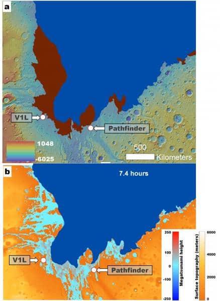
(a) Map of the older two possible megatsunami deposits (red-shaded areas) mapped by Rodriguez et al. 2016 (https://www.nature.com/articles/srep25106). The dark blue area corresponds to the ocean with a paleoshoreline at approximately 3,800 meters. In addition, the locations of the Viking 1 and Pathfinder landers are indicated. Credit: MOLA Science Team/MSS/JPL/NASA.
(b) Simulation showing a megatsunami generated by the formation of the Pohl crater 7.4 hours after the impact. Notice how the wave reaches the landing sites. Credit: MOLA Science Team/MSS/ JPL/NASA.
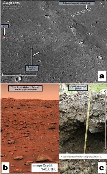
(a) Perspective view showing the location of the Viking 1 Lander (V1L) on a highland-facing sedimentary lobe. The image is part of a Mars Reconnaissance Orbiter (MRO) Context Camera. Credit: NASA/JPL/Malin Space Science Systems/ Google Earth/PSI.
(b) Lander view of rocky plains, a stunning landscape without the then-expected fluvial features. Image Credit: NASA/JPL.
(c) View of tsunami deposit gravel, similar to the rocky plains imaged by the V1L. Credit: Goto et al. (2012).
Media Contact
Alan Fischer
Public Information Officer
520-382-0411
[email protected]
Science Contact
Alexis Rodriguez
Senior Scientist
[email protected]